Geography (Maztica Supplement)
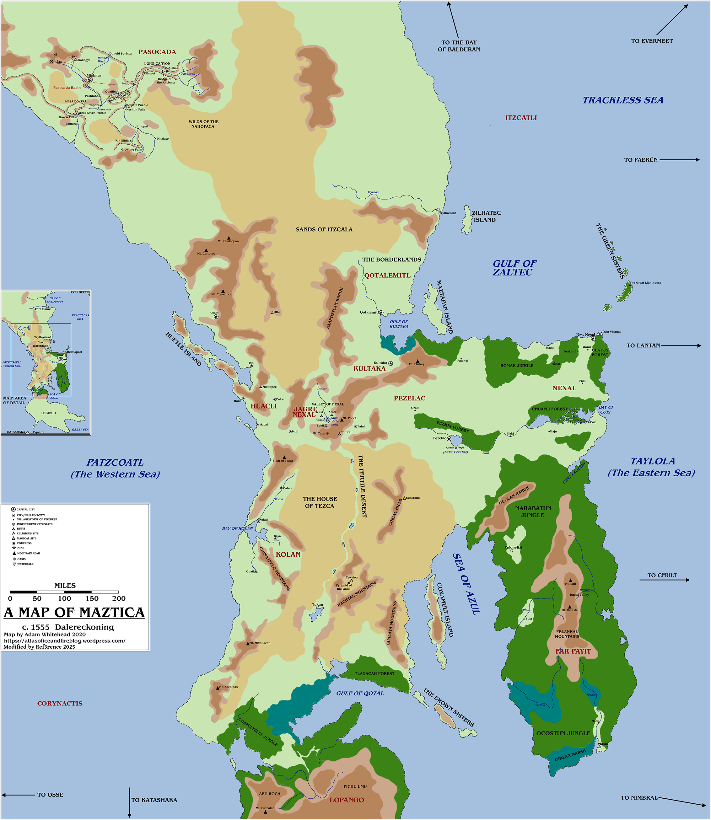
Geographical Map[edit]
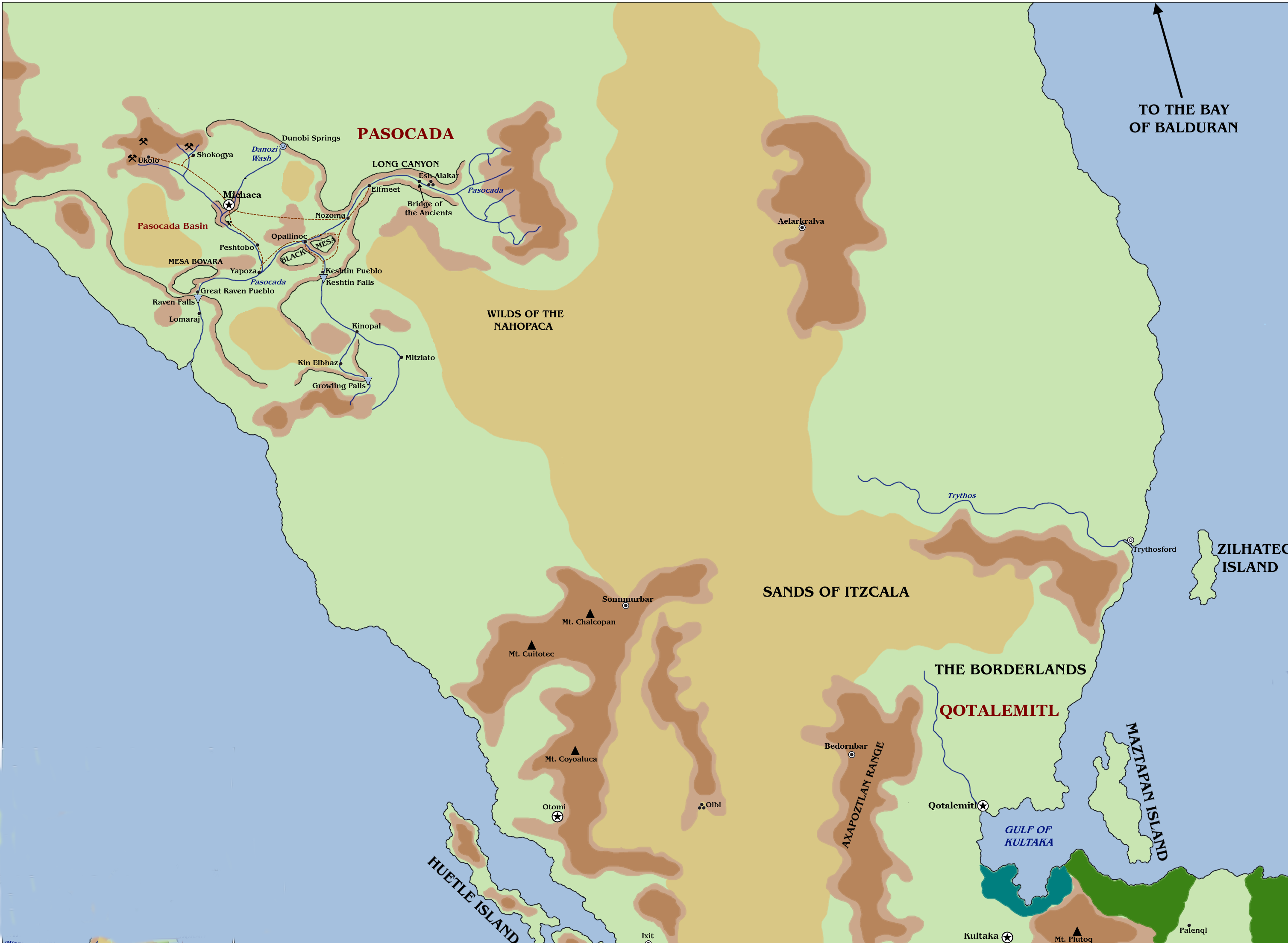
Northern Maztica[edit]
- The Pasocada Basin is a fertile valley cut from the Sands of Itzcala by the Pasocada river system. The basin is a land of rivers and mesas; of waterfalls and valleys. In its isolation, it has given rise to a thriving civilization distinct from its southern cousins.
- The Long Canyon descends from the mountain Pasocada and stretches ninety miles to the basin's heart. The valley's rapids have few inhabitants, and what few it has can survive being dashed against the river's jagged rocks as a prerequisite. Beyond the river, the valley is home to a number of hungry hill giant clans.
- Esh Alakar is the ruins of an ancient open air complex within the Long Valley. It is believed that the original Esh Alakarans, whatever they may have been, destroyed themselves in a grand magical battle, and some surface level similarities in its construction have been drawn to the poscadar elves and the enigmatic Pyramid of the Gods. While all that remains above ground is partial walls, shattered pottery, and the Bridge of the Ancients (one of the few safe crossings in the valley), the ruins hide a vast underground network rife with stone statues and swarm of poisonous snakes (believed to be the complex's original inhabitants and their descendants), specters and ghosts, stone golems, and untold numbers of magical traps and gemstones (some of which might still contain the souls of Esh Alakarans).
- The Dunobi Springs are magical wells of endless water that flows from Wenimats into the Pasocada river system, the divine domain of Miochin and the other Azuposi gods. Along with water, magical pollen and corn meal occasionally flow from the springs. Each harvest season, these materials combine with the dripping sap and pollen from the trees to become micha, which is not only a potent fertilizer, the food of spirits and magic.
- There is a ritual known to some pascodar sages that when one covered in the sand from the Sun Valley that the springs flow down and sprinkled with micha bathes in the waters, it forms a golden path to the Sun Trail, a 15-foot wide, many miles long cornmeal road through the Astral Plane ending in a green pool leading to Wenimats.
- The Growling Falls is a 200-foot waterfall along the southern tip of the Pasocada Basin. Its name comes from the legend of the hero Incholcpa (Hinchapa among the Azuposi), a human who wrestled an evil bear demigod, thought by some to be a bearlike fiend such as a stray pit fiend or balor, into submission at the foot of the falls. If the legends are to believed, the great bear's growls can still be heard within the roar of the falls.
- The Wilds of the Nahopaca, often simply called the Nahopaca (though this often causes confusion between the region and the nomadic Nahopaca that occupy the region), is the westernmost region of the Sands of Itzcala and the closest to the Pasocada Basin. The region is a winding maze of mesa canyons filled with tangling shrubbery, and one would be fortunate not to run into one of the region's orange-scaled hakuna.
- The Sands of Itzcala is a massive desert that covers most of northern Maztica. Much of the region is rolling hills of sand and cacti inhabited primarily by hungry coyotes, vultures, and their humanlike kin. Heat stroke alone has claimed many wanderers who travel the sands, and some hills are rumored to burn hot enough to boil water at midday.
- The river Trythos flows out to the sea north of the Borderlands. Its exact origin is unknown; it decidedly does not flow from any known Borderlands mountain, and nobody has journeyed to its source and returned.
- Zilhatec Island, sometimes called the disappearing island, is a nearly fifty mile long sandbar that regularly floods completely at high tide. Its surface sustains a moss-like grass that can survive being fully submerged or fully exposed to air for months, though it flourishes most with a daily cycle of both.
- The Borderlands is a series of three ranges of steep mountains separated by the Sands of Itzcala: Axapotzlan shielding Qotalmitl and Kultaka from the desert, the copper-rich Mount Chalcopan and its daughter peaks Mounts Cultotec and Coyoaluca cradling Otomi and creating a dangerous choke point across the desert, and the Borderlands Mountains themselves separating Trythosford from the rest of Maztica. All three ranges are dangerous not only due to the possibility of rock slides and steep cliffs, but the high population of rhaumbusun in the area.
- Olbi is a set of ruins located in the center of the southern Sands of Itzcala. It predates both Esh Alakar and Tehwaca and consists of a series of smooth-walled caves, the likes of which would require metal tools or advanced magic. The main tunnels have been all but emptied of their riches save for a collection of statues, most of which resemble the gods of Maztica and reside in the complex's central chamber while others are spread throughout and are nearly unrecognizable to most Mazticans, but it is well known that many secret passages and tombs containing magic items as powerful as their guardians go unlooted.
- Maztapan Island splits entry and exit to the Gulf of Kultaka into two channels. During the Age of Slavery, it was used as a mooring site by New Waterdeep, modern day Qotalemitl. With the dereliction of much of the invaders' ships, it has become the site of Qotalemitl's attempts to create a grand Maztican navy.
- The Gulf of Kultaka is the furthest inland the eastern sea penetrates above Far Payit. To the south of the gulf, dangerous salt marshes cut the central Maztican population off from the sea, but also provides a varied testing ground for would-be jaguar and eagle knights. On the northern bank, Qotal's river creates rapid transit from scattered river farms to the regions capital city, and is fairly tame.
- Huetle Island was once part of Huacli's western archipelago before some cataclysmic event severed it from the mainland, as attested by numerous scholars who have declared the underwater canyon separating it to be an unnatural formation. The exact cause of this severance is contested, with some claiming it to have been caused by a stray blow during Qotal and Zaltec's legendary battle, others by ancient Corynactian siege krakens, and yet others by Hinchapa's bear fiend.
- Anchôromé: the Sands of Itzcala and Borderlands Range cause travel north of Northern Maztica to be nearly impossible, though it is known that the fabled land of Anchorome lies beyond them. Even beyond Maztica, rumors persist of a land of dragons, ancestral birdmen, isolationist elves, and nomadic thri-kreen.
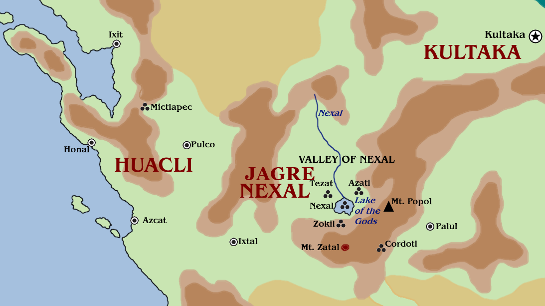
Central Maztica[edit]
- The Valley of Nexal is formed from a ring of volcanic mountains with one narrow valley to the northeast and another to the southwest. The river Nexal flows from the north to feed the Lake of the Gods, which has long since been split into Lakes Qotal, Zaltec, Azul, and Tezca via four artificial land bridges. The lakes are the primary cipactli breeding ground, making entering and exiting the central island of Nexal a test for even the strongest eagle knights, though one could also try their luck navigating the likely-collapsed aqueducts dug from the island's temples and palaces to Mount Zatal's rivers.
- Mount Zatal is the holy volcano of Zaltec. The peak considered Mount Zatal is known to have moved, creating the Zatal Range, having first been north of the Lake of the Gods, then what is now known as Mount Popol, before finally resting in its current location. The range is covered in warm-to-the-touch lava tubes, some holding entire rivers, lakes of magma, pools of molten metal, and all manner of mysterious monsters.
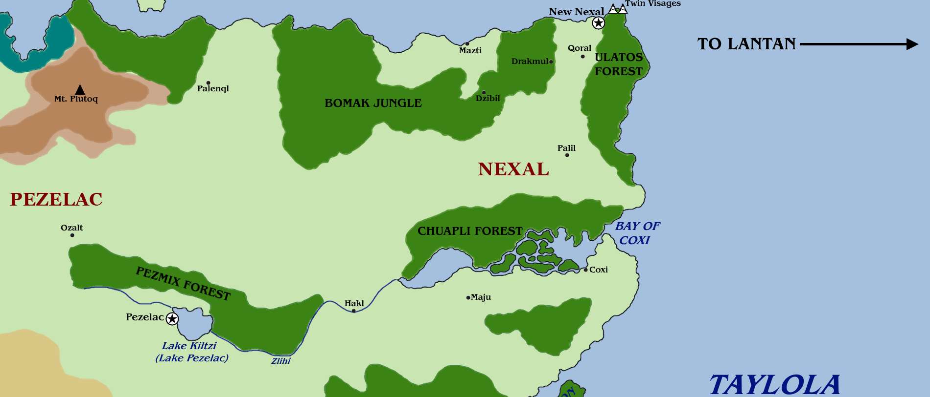
Eastern Maztica[edit]
Eastern Maztica is home to two powerful members of the Nine Nations, and is the only land-based path to Far Payit, resulting in frequent skirmishes. Its terrain if fairly flat, with only a few rolling hills and only a single mountain across the entire region. Its coasts are continually hounded (or perhaps haunted) by seawolves, while hakuna stalk its lakes and rivers, while red wolves stalk the planes for capybara, bearded monkies, and tapirs.
- The Twin Visages sit just to the north of New Nexal's harbors, and are a set of two grand faces carved into the cliffside, one male and one female. The identity of these faces is contentious; some claim them to be Kukul and Maztica, while others claim them to be Inti and Sus'sistinako, and yet others Miochin and Shaka.
- The Ulatos Forest bears the name of New Nexal from before it was conquered. During the Age of Slavery, Payit rebels used their knowledge of the forest to smuggle allies out of Amnian territory to sail to Far Payit. To this day, it is a common staging ground for Payit raids, both from the human kingdom and halfling tribes of the peninsula.
- The Bomak Jungle has a higher than average population of green chacna, resulting in near-constant rainfall sometimes bordering on torrential.
- Mount Plutoq acts as a natural barrier between Kultaka and Pezelac. The chacna of the Bomak Jungle make pilgrimage to its caves to celebrate births.
- The Bay of Coxi flows into the Pezel River through a series of deltas and lakes that are considered part of the bay. To this day, large tunnels remain from the star worm H'Calos' rampage through the region.
- The Chuapli Forest covers almost the entire northern bank of the Bay of Coxi. Being so rife with jaguars and constrictor snakes, it acts as a natural barrier between New Nexal and Pezelac.
- The Pezmix Forest, once a part of the Chuapli Forest, was separated from the larger forest in a deliberate effort to fortify the area during Zaltec's conquest following Qotal's banishment.
- The Pezel River flows down from the slopes of the ever-rainy Pezmix Forest, gathering in Lake Kiltzi before depositing into the Bay of Coxi. While much of the river is thankfully devoid of hakuna, ahuizolt and rarely even cipactli threaten those who journey too far from the walls of its river towns.
- Lake Kiltzi, also called Lake Pezel, is the heart of Pezelac. While the lake itself is plentiful with birds and fish, including the occasional quipper, it is fairly shallow and lines with reeds where they are not deliberately trimmed. The lake itself is seemingly enchanted to draw storms, even without the obvious interference of tlalocoatl or chacna, often extending to the slopes of Pezmix and causing it to flood regularly, becoming the primary source of the Pezel River and creating fertile farmland around the lake, making it one of the few regions not dependent on slash-and-burn farming.
Southern Maztica[edit]
Southern Maztica is the heartland of the Kolan Empire...
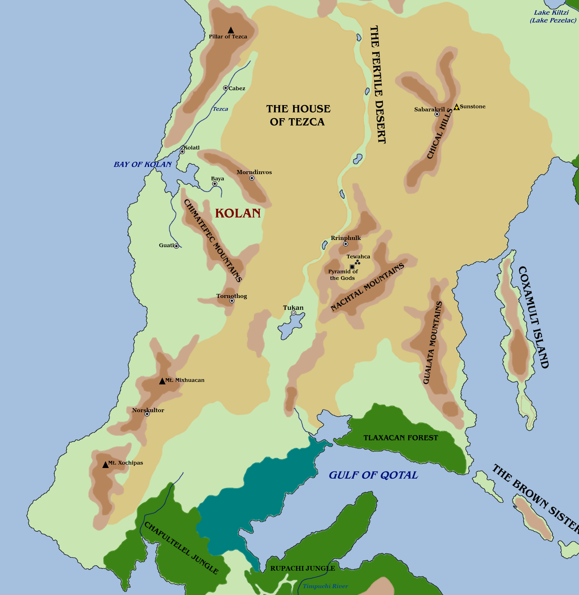
- The House of Tezca is one of the two great deserts of Maztica. Named after Tezca, the Maztican god of fire and the sun, the desert's surface temperature can easily reach over half way to boiling in the summer sun, with some regions being wholly unable to support life long-term, and drop below freezing on most winter nights. Rain is almost unheard of due to the numerous mountains that border it. What little wildlife the House has is mostly lizards, rhaumbusun, and harpies.
- The Pillar of Tezca is a great mountain along Maztica's western coast. It is a major haven for chacna and plumazotl, and its peak has been used historically as a major scouting site.
- The Fertile Desert is a swathe of water and vegetation cut through the House of Tezca by Qotal upon his return to lead civilians out of Old Nexal. Compared to the rest of the House of Tezca, it is awash with lakes, plant life, and tapirs, and is a common landing place for harpies.
- The Tezca River flows from the falls of the Pillar of Tezca to the Bay of Kolan, creating a wide, verdant plain, which is home to large populations of peacocks and jackals.
- The Chical Hills are the shortest of the House of Tezca's mesas. It is most notable for the Sunstone, a circular lake of silver that sits on their eastern banks, roughly 200-yards in diameter. It is said that anyone who sits at its shores at noon will receive a vision, as per the divination spell. If they are pure in their intentions these visions are truthful, but if their intentions are impure, clouded by greed or hate, the visions are misleading, sometimes even leading the seeker to their death. Touching the silver in any way, even with an object, causes a creature to be teleported to a random location in the House of Tezca.
- The Bay of Kolan is the heart of the Kolan Empire, with its four core cities either sitting on the bay itself or the rivers that flow into it. It empties into Patzcoatl, the Western Ocean, via a cliff-walled strait, making it incredibly defensible to naval invasions, and incredibly useful for naval staging. It is said that nothing moves in the Bay of Kolan without the empire willing it.
- The Chimatepec Mountains consist of two strings of mesas, sometimes four when including the Pillar of Tezca and Mount Mixhuacan though this inclusion is contentious for multiple reasons including that they are not mesas, that split the land around the Bay of Kolan into three lowland prairies. Harpies in these areas are said to be particularly bold.
- The Nachtal Mountains create a circular valley that is only accessible easily from the north, and with some difficulty from the west and south. Within it is the ruins of Tewahca, an ancient city erected around the Pyramid of the Gods, Maztica's throne atop which it is said that Zaltec and Qotal had their legendary battle. It is said that no human ever inhabited Tewahca, though what this means for the numerous homes and tombs the city holds is a mystery.
- Coxamult Island, formerly the Coxamult Peninsula, is a large island in the Sea of Azul, off Southern Maztica's eastern coast. It has a surprisingly large hakuna population.
- The Gualata Mountains are a stretch of mesa plateaus along the Sea of Azul that, alongside the Tlaxacan Forest and the northern swathe of the House of Tezca, makes landing actions along the Sea of Azul nearly fruitless.
- Mount Mixhuacan is a metal rich mountain along southern Maztica's western coast, and is the most extensively mined mountain in Maztica.
- Mount Xochipas, in contrast to its northern twin Mixhuacan, is almost devoid of useful materials save for large clay deposites, and has only seen limited desert dwarf explorations.
- The Gulf of Qotal sits to the south east of mainland Maztica. It is said that on the Night of Wailing, after guiding his people through the Fertile Desert and looking upon Tewahca for the first time in centuries, he took his rest in the gulf.
- The Tlaxacan Forest is southern Maztica's only major woodland. Since Qotal rested in the gulf to the forest's east, it has become dense with coatl.
- The Brown Sisters are a chain of islands that were once part of the mainland. To this day, one can still walk from island to island through shin-high water at low tide. Due to this, inhabitants of the surrounding area sometimes refer to them collectively as the Island of Lost Children.
Far Payit Peninsula[edit]
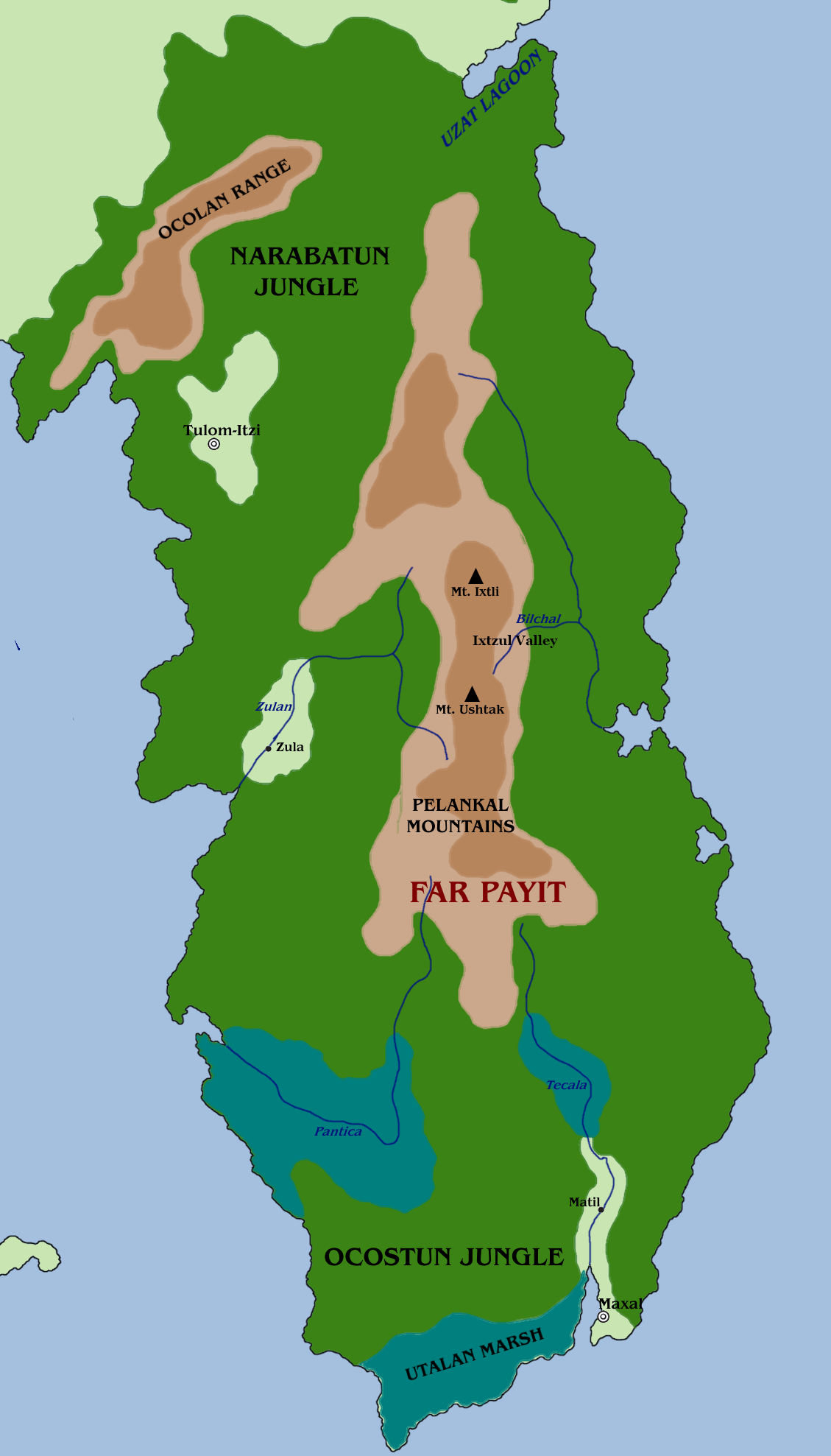
The Far Payit Peninsula, located to the south of Eastern Maztica's east coast, in primarily jungle, though mountains and marshlands also take up large swathes of land. As Maztica's largest jungle, it is home to the greatest number of monkeys, treants, harpies, and coatls.
- The Narabatun Jungle covers most of Far Payit. While it is thick with foliage and wildlife, paths snake their way through the jungle, though they can be nearly invisible unless one is actively walking it. In addition to the nation of Far Payit, tribes of tabaxi and payit halflings, many of which are lead by jaguar lords, have made the Narabatun their home.
- The Uzat Lagoon is a wide area of shallows that sees many spear-fishers and is considered rather pleasant, though it could easily become the home of a cipactli. Many bungalows along its coast are inhabited by werejaguars, and are considered forbidden. Kelpies are also most common here.
- The Ocolan Range is a stretch of small, rocky hills leading south to Mount Ocolan, Maztica's lowest mountain.
- The Pelankal Mountains can be seen from nearly any treetop or hilltop in Far Payit. The valley between its two main peaks, Mount Ixtli and Mount Ushtak, is said to be the site of Maztica's first wound in her battle against Zaltec.
- The Ixtzul Valley is a five-mile long valley along the southeastern side of the Pelankal Mountains, having been cut into the mountainside by the Tecala River. Within this valley is the lost city of Ixtzul, now overrun with bacar.
- The Ocostun Jungle covers the southern tip of Far Payit, and is cut off from the Narabatun by the southern coast, the Pantica and Tecala Rivers, and the thick marshes teeming with kamatlan and giant crocodiles that they feed.
Lopango Peninsula[edit]
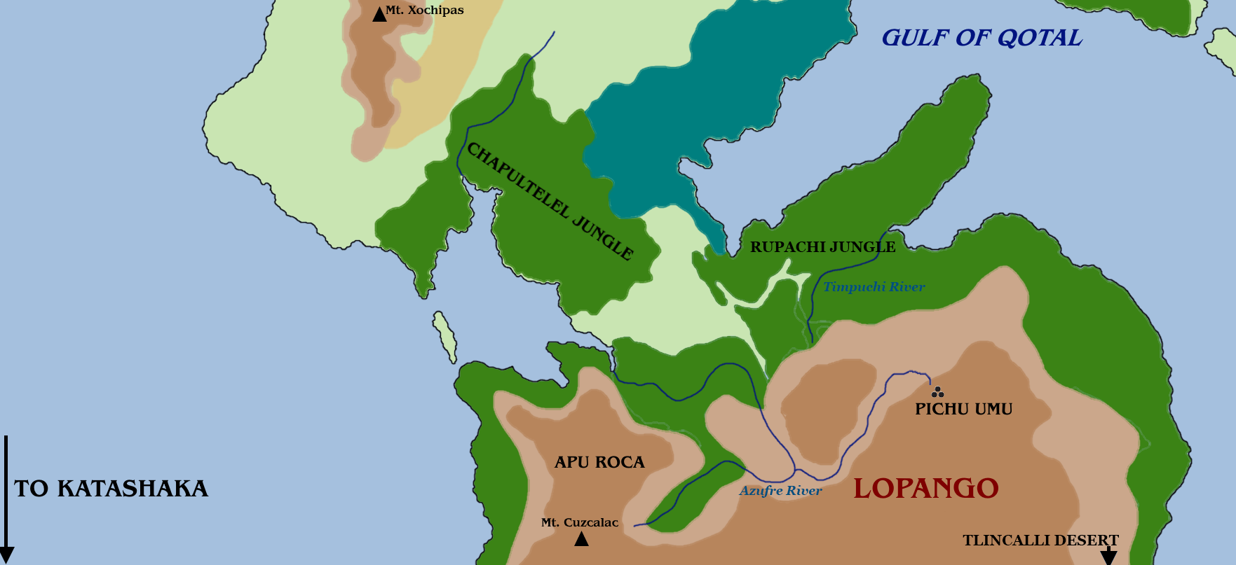
The Lopango Peninsula is the southern-most landmass of Maztica. Its name roughly translates to "Land of Fire", hearkening to its long history of volcanic activity.
- The Chaputlelel Jungle is the only land connection from Lopango to the rest of Maztica. Its treants are considered particularly greedy.
- The Rupachi Jungle runs along the coastline of Lopango. As a result of regular forest fires, it is the youngest jungle in Maztica. Any old growth should be approached with caution; they are likely to be inhabited by a tabaxi clan, possibly even one lead by a jaguar lord.
- The Azufre River flows from the lake at the peak of Mount Cuzcalac, and deposits into Chaputlelel Bay and the mouth of Pichu Umu.
- The Timpuchi River flows from the side of a rocky cliff in the northern side of the Apu Roca range, and is notably hotter than the rest of Maztica's rivers.
- Apu Roca, the "Lord's Rock", is a great volcanic mountain range that dominates the northern half of central Lopango. Some scholars trace its name back to legends of "Kayra Apu", ancient frog-like humanoids, potentially Slaadi, said to have warred against the ancient Mazticans and their gods.
- Pichu Umu, the "Mountain Head", is a great stone carving of a face in the side of one of Apu Roca's mountains. The face is split in half lengthwise, with one half being said to be Azul's and the other Tezca's, though some scholars posit this may be Kukul and Maztica, whom the twins are said to resemble. It is unknown who carved the monument, or for what purpose. On heavy rain falls and earthquakes, steam is said to billows from Pichu Umu's eyes.
- Mount Cuzcalac is the highest, and likely youngest, mountain in Apu Roca. At its peak is a great lake created and ruled by the largest of Azul's Tlalocoatl cults.
- The Tlincalli Desert dominates the southern half of central Lopango. While it is home to the largest unsullied region of the Maztican Underdark, it has long been claimed by the tlincalli.
- Katashaka: the violent Straits of Taba off the Lopango Cape make sailing further south nearly impossible, though it is known that the so-called "Dark Continent" lies beyond them. Even beyond Maztica, rumors persist of a land of titans and the birthplace of humanity.
Other Locations[edit]
- The Underdark of Maztica is nearly uninhabitable, having been flooded with toxic, burning fumes in the late 10th century DR due to drow newcomers experimenting with the Darkfyre of Mount Zatal. Unsullied pockets are few and far between, and highly coveted as the only sources of the continent's very limited sources of high-quality metal ore.
- Patzcoatl, sometimes called the Western Ocean, is the great sea to the west of Maztica. The ocean provides a bounty of fish, mussels, shells, and whales to those brave enough to fish it. Far off the Maztican cost, nearest to the coast of Mount Xochipas in Southern Maztica, lies the Sea of Corynactis, a deep-sea realm long conquered by As'Dagon.
- Taylola, sometimes called the Trackless Sea, is an ocean to the east of Maztica. While its provides many more reef sharks and seawolves than whales, it is also home to selkies and kelpies, especially in its northern regions. Much more predominant in the northern region are the sahuagin of Itzcatil.
Back to Main Page → 5e Homebrew → Campaign Settings → Maztica
